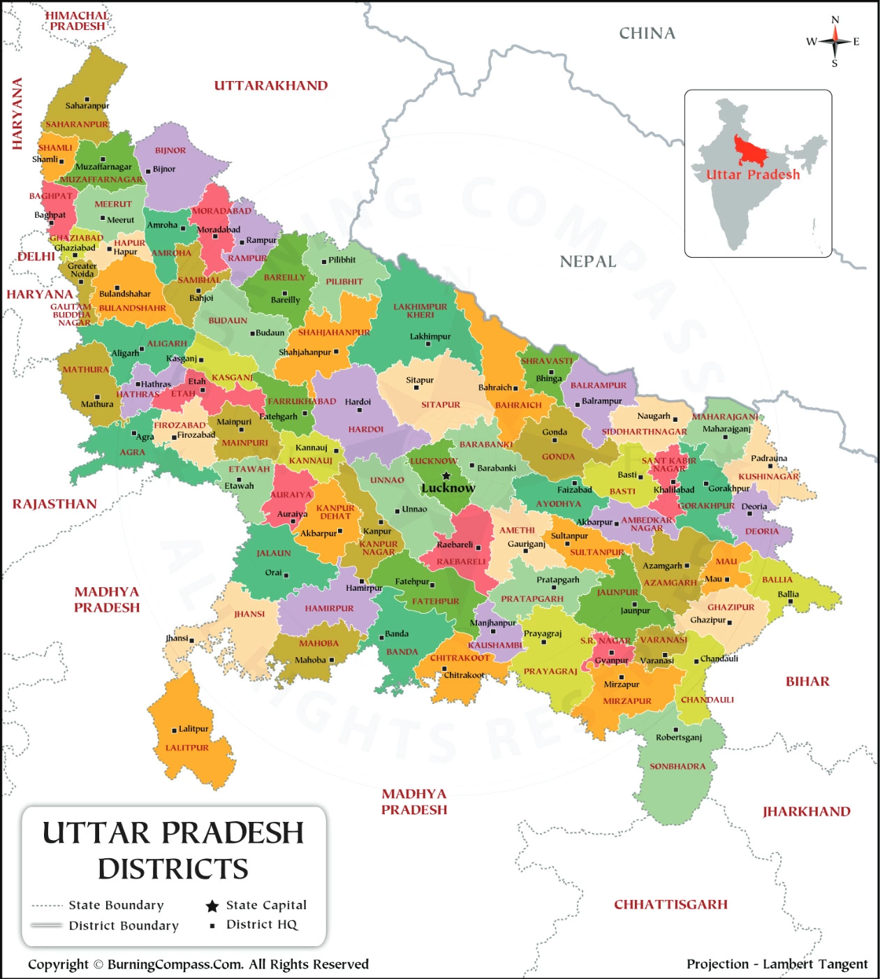
UP District Map HD
Uttar Pradesh (UP) is a large state with diverse geography, ranging from the plains of the Ganges to the foothills of the Himalayas. Districts may differ in terms of terrain, rivers, and natural resources.
Every district has a headquarters where administrative offices are located. These headquarters serve as the central point for governance within the district.
UP District Name List
| S.NO | Districts of Uttar Pradesh | Area (sq km) |
|---|---|---|
| 1 | Agra | 4,041 |
| 2 | Aligarh | 3,788 |
| 3 | Allahabad | 5,482 |
| 4 | Ambedkar Nagar | 2,350 |
| 5 | Amethi | 2,651 |
| 6 | Amroha | 2,249 |
| 7 | Auraiya | 2,016 |
| 8 | Azamgarh | 4,054 |
| 9 | Badaun | 4,234 |
| 10 | Bagpat | 5,237 |
| 11 | Bahraich | 2,981 |
| 12 | Ballia | 3,349 |
| 13 | Balrampur | 4,408 |
| 14 | Banda | 4,402 |
| 15 | Barabanki | 4,120 |
| 16 | Bareilly | 2,688 |
| 17 | Basti | 4,561 |
| 18 | Bijnor | 4,262 |
| 19 | Bulandshahr | 4,441 |
| 20 | Chandauli | 2,541 |
| 21 | Chitrakoot | 3,216 |
| 22 | Deoria | 2,540 |
| 23 | Etah | 2,431 |
| 24 | Etawah | 2,311 |
| 25 | Faizabad | 2,341 |
| 26 | Farrukhabad | 2,181 |
| 27 | Fatehpur | 4,152 |
| 28 | Firozabad | 2,407 |
| 29 | Gautam Buddha Nagar | 720 |
| 30 | Ghaziabad | 1,179 |
| 31 | Ghazipur | 3,377 |
| 32 | Gonda | 4,003 |
| 33 | Gorakhpur | 3,321 |
| 34 | Hamirpur | 4,021 |
| 35 | Hapur | 649 |
| 36 | Hardoi | 5,986 |
| 37 | Hathras | 1,840 |
| 38 | Jalaun | 4,565 |
| 39 | Jaunpur | 4,038 |
| 40 | Jhansi | 5,024 |
| 41 | Kannauj | 2,093 |
| 42 | Kanpur Dehat | 3,021 |
| 43 | Kanpur Nagar | 3,155 |
| 44 | Kasganj | 1,955 |
| 45 | Kaushambi | 1,779 |
| 46 | Kushinagar | 7,680 |
| 47 | Lakhimpur Kheri | 2,905 |
| 48 | Lalitpur | 5,039 |
| 49 | Lucknow | 2,528 |
| 50 | Maharajganj | 2,952 |
| 51 | Mahoba | 3,144 |
| 52 | Mainpuri | 2,760 |
| 53 | Mathura | 3,340 |
| 54 | Mau | 1,713 |
| 55 | Meerut | 2,559 |
| 56 | Mirzapur | 4,405 |
| 57 | Moradabad | 2,233 |
| 58 | Muzaffarnagar | 2,742 |
| 59 | Pilibhit | 3,686 |
| 60 | Pratapgarh | 3,717 |
| 61 | Rae Bareli | 3,937 |
| 62 | Rampur | 2,367 |
| 63 | Saharanpur | 3,689 |
| 64 | Sant Kabir Nagar | 2,390 |
| 65 | Sant Ravidas Nagar | 1,646 |
| 66 | Sambhal | 1,015 |
| 67 | Shahjahanpur | 4,388 |
| 68 | Shamli | 1,266 |
| 69 | Shravasti | 1,640 |
| 70 | Siddharthnagar | 2,895 |
| 71 | Sitapur | 5,743 |
| 72 | Sonbhadra | 6,905 |
| 73 | Sultanpur | 2,457 |
| 74 | Unnao | 4,558 |
| 75 | Varanasi (Kashi) | 1,535 |