Political Map of India 2026
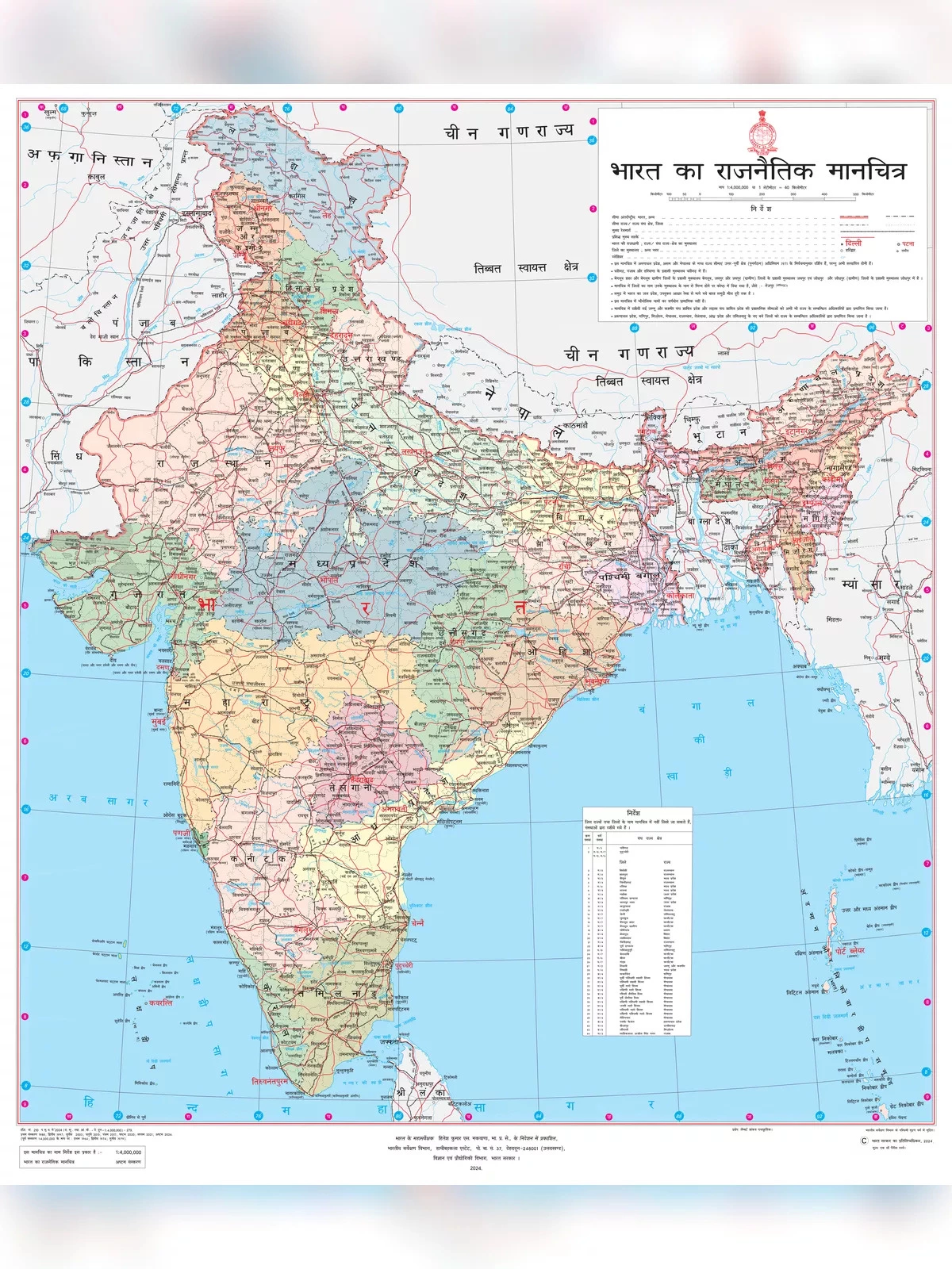
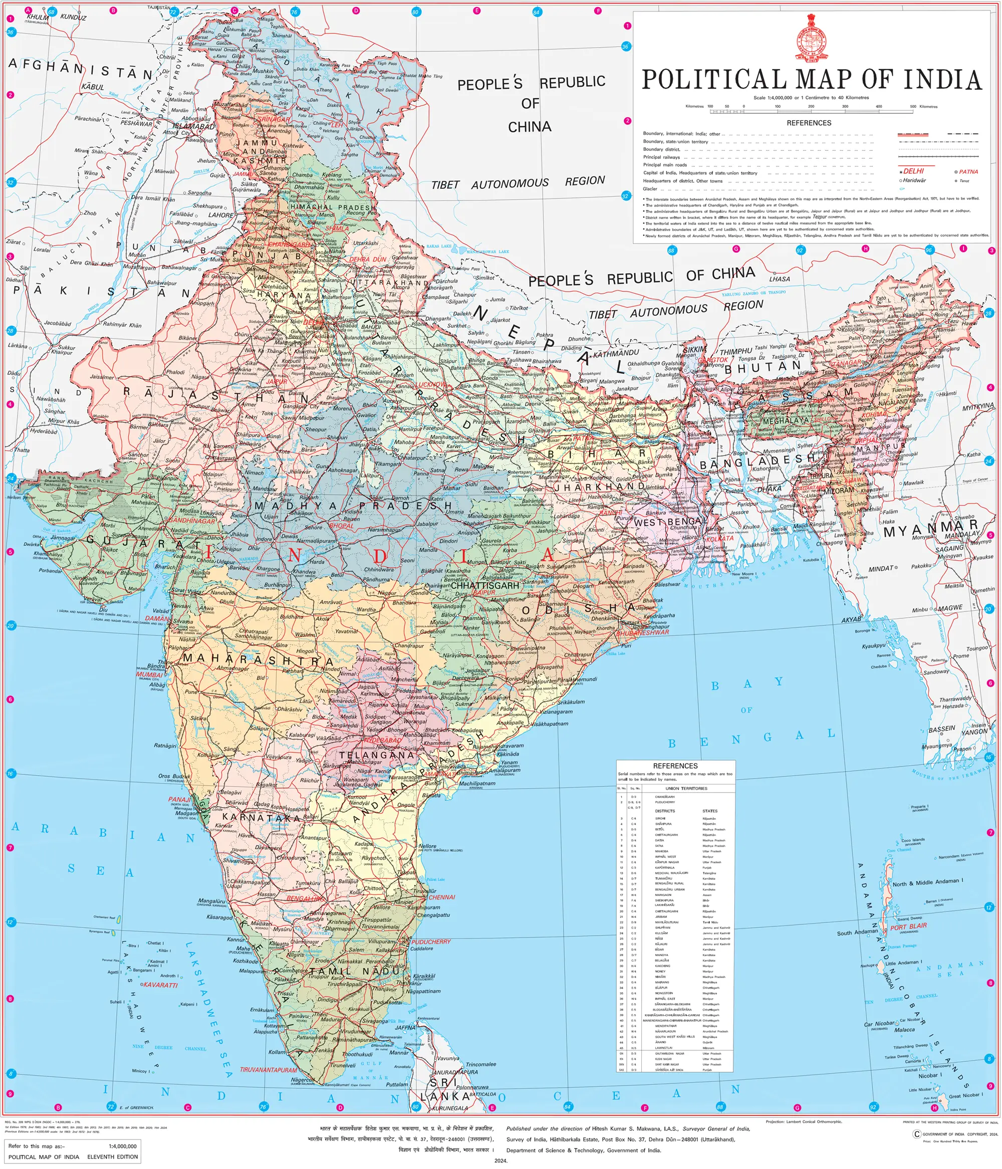
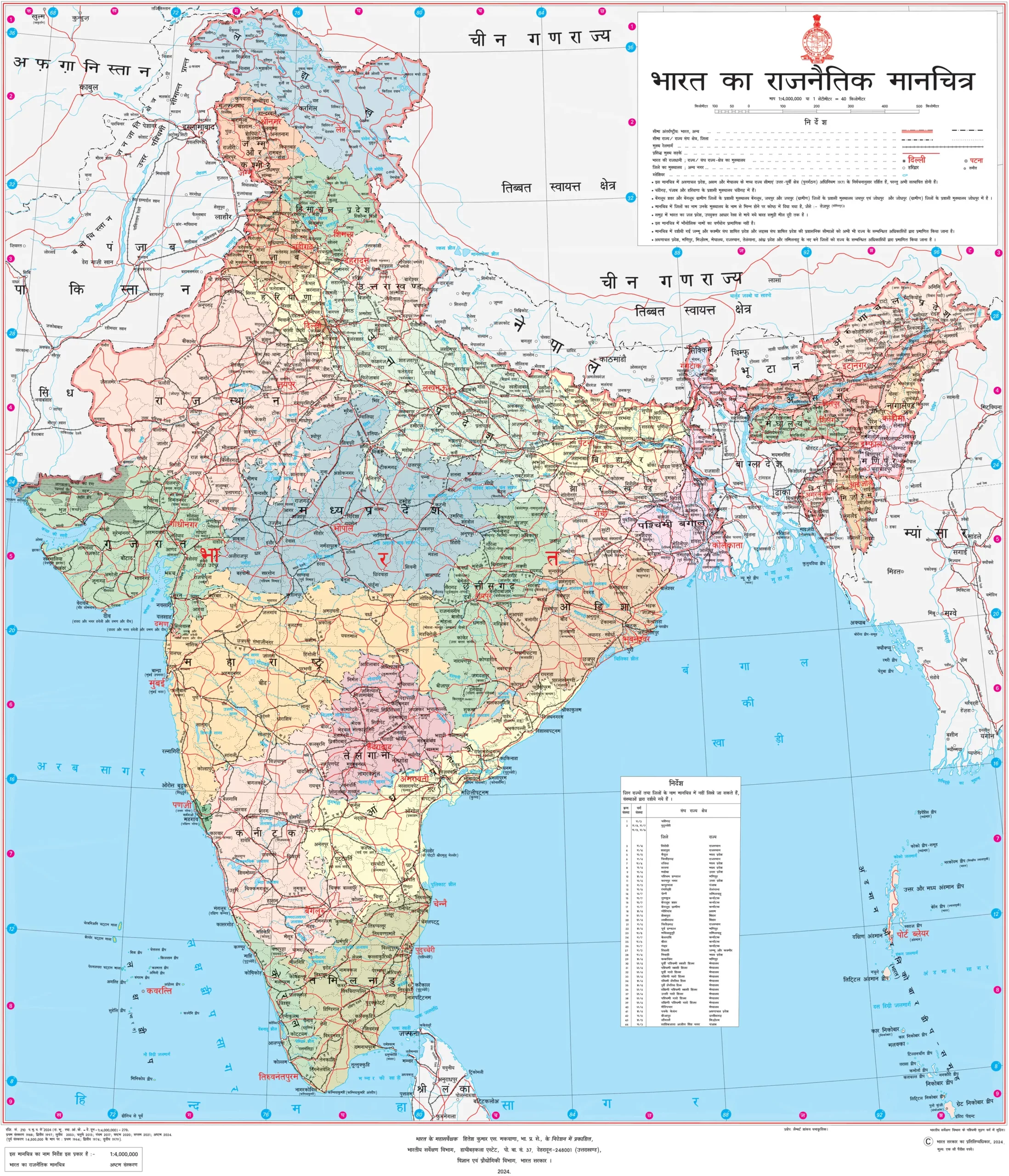
India’s Political map (भारत का राजनैतिक मानचित्र) presents a detailed view of all the states and union territories of India, along with their capital cities. The Indian naval hydrographic charts also reveal that India’s mainland coastline is composed of 43% sandy beaches, 36% mudflats, 10% marshy shores, and 11% rocky shores.
This PDF of the Indian Political Map 2026 features the map available in both Hindi and English languages for easy understanding.
Discover the Latest Political Map of India – भारत का राजनैतिक मानचित्र 2026
India is the second most populated country in the world and the largest democracy globally. The country’s coastline stretches an impressive 7,517 kilometers, with 5,423 kilometers belonging to peninsular India and 2,094 kilometers attributed to the Andaman, Nicobar, and Lakshadweep island chains. In Eastern India, you will find the states of Bihar, Jharkhand, Odisha, West Bengal, along with the union territory of Andaman and Nicobar Islands.
The western region of India spans a total area of 508,052 sq km. Popular states in this region include Gujarat, Goa, and Maharashtra, along with the Union Territories of Dadra & Nagar Haveli and Daman & Diu. Mumbai, which is known as the financial capital of India, serves as the capital of Maharashtra.
In North India, the states consist of Himachal Pradesh, Uttar Pradesh, Uttarakhand, Punjab, and Haryana, including the union territories of Delhi (National Capital Territory), Chandigarh, Ladakh, and Jammu and Kashmir.
Southern India comprises states such as Tamil Nadu, Karnataka, Kerala, Andhra Pradesh, and Telangana, along with the union territories of Lakshadweep and Puducherry.
High-Resolution Political Map of India – English
This is the official political map of India issued by the Survey of India, a department of the Indian Government. To download the high-resolution version of this map, simply click on the image itself. The PDF download can be accessed through the button below or directly from the Survey of India’s official website at surveyofindia.gov.in.
High-Resolution Political Map of India – Hindi
You can download the high-resolution Indian Political Map in Hindi by clicking on the image below.
Benefits of the Indian Political Map
The Political map of any country, including India, is an essential resource for a variety of professionals, students, researchers, government officials, travelers, and many more. Here are some common uses for a political map of India:
- Understanding Geography: A high-resolution political map of India helps people grasp the country’s geography. It displays state boundaries, cities, and significant features such as rivers and mountains.
- Educational Purposes: Schools and educational institutions utilize these maps to teach students about India’s political divisions, helping them learn about states, capitals, and major cities.
- Travel Planning: Travelers rely on political maps to prepare their trips within India. These maps illustrate the locations of various states, cities, and attractions, aiding in their travel decisions.
- Business and Economics: Companies employ these maps for market research and strategic planning. Identifying potential markets, distribution channels, and areas for growth is essential based on political borders and demographics.
- Government and Administration: Government agencies rely on political maps for administrative functions, playing a critical role in planning and implementing policies, infrastructure projects, and resource distribution across regions.
- Research and Analysis: Researchers leverage political maps to examine various aspects of India, such as population trends, economic growth, political dynamics, and social changes. The detailed data from these maps informs their conclusions and decisions.
Overall, a high-resolution political map of India is not just a visual aid but a powerful tool for education, travel, business, governance, and various other fields, enhancing understanding and navigation of India’s political landscape.
Get the Latest Political Map of India PDF Download from the link below.