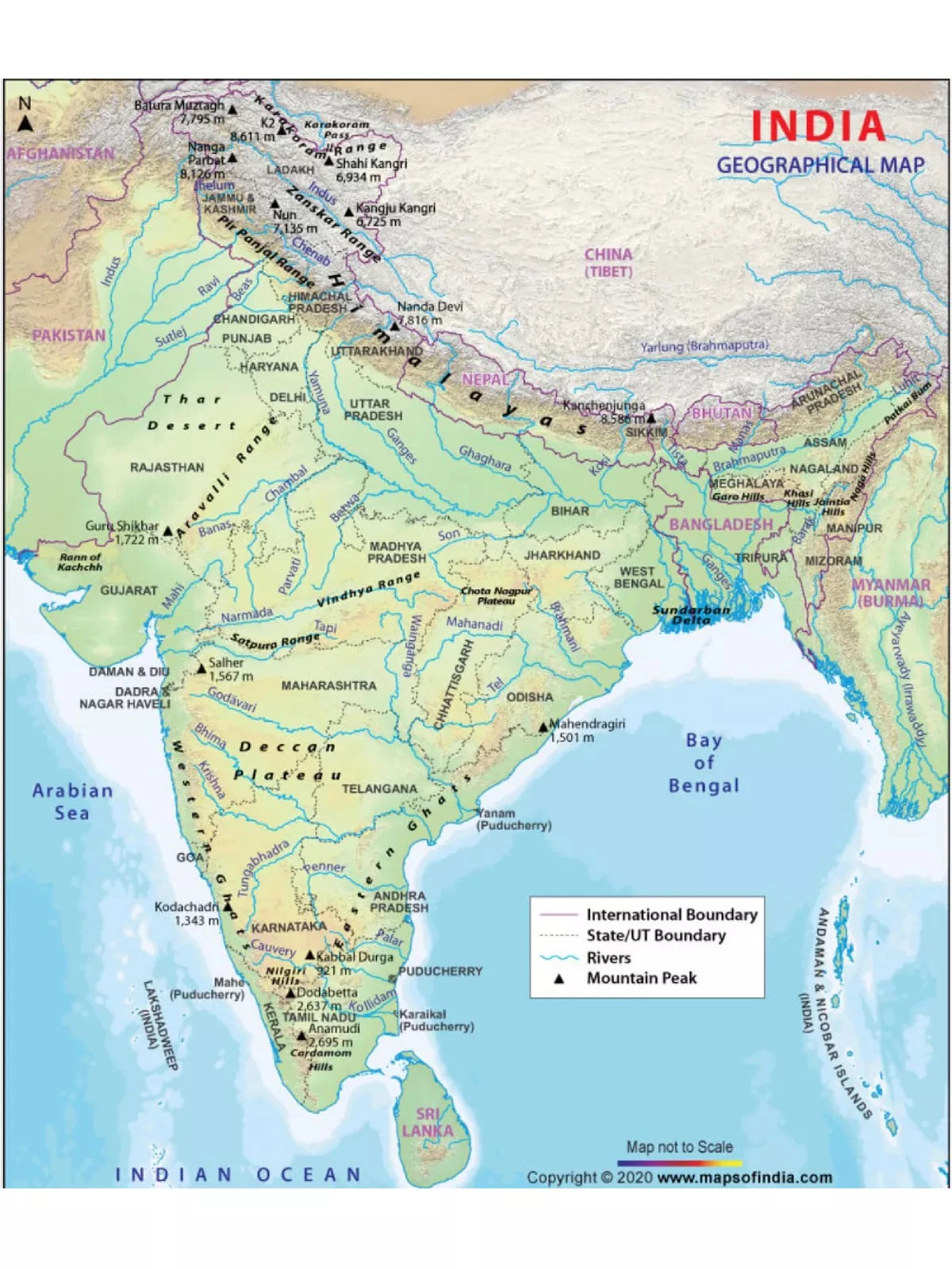
India Map with Rivers and Mountains
The Indian Mountain Map PDF provides a clear and informative view of the geographical locations of India, including rivers, mountain ranges, mountain peaks, state boundaries, and state names. As the seventh-largest country in the world by area, India rests on the Indian Plate, a part of the larger Indo-Australian Plate. This Indian Mountain HD Map PDF can assist you in identifying the majestic mountains across the country.
Understand India’s Geography Better
India’s mainland stretches between 8°4′ and 37°6′ N latitude and 68°7′ and 97°25′ E longitude. The Tropic of Cancer, located at 23°30′ N, almost divides India into two equal halves. The nation boasts a total coastline of 7,517 kilometers. As the Indian peninsula narrows towards the south, it divides the Indian Ocean into two significant water bodies: the Bay of Bengal and the Arabian Sea. India showcases a diverse range of landforms, including tall mountains, deep valleys, vast plains, plateaus, coastal ghats, deserts, and numerous islands. 🌏
India Mountains Name List – Top Mountains in India
| Mountain | Height (M) | Range | State Name |
|---|---|---|---|
| Kangchenjunga | 8586 | Kangchenjunga Himalaya | Sikkim |
| Nanda Devi | 7816 | Garhwal Himalaya | Uttarakhand |
| Kamet | 7756 | Garhwal Himalaya | Uttarakhand |
| Saltoro Kangri/K10 | 7742 | Saltoro Karakoram | Jammu and Kashmir |
| Saser Kangri I/K22 | 7672 | Saser Karakoram | Jammu and Kashmir |
| Mamostong Kangri | 7516 | Rimo Karakoram | Jammu and Kashmir |
| Saser Kangri II E | 7513 | Saser Karakoram | Jammu and Kashmir |
| Saser Kangri III | 7495 | Saser Karakoram | Jammu and Kashmir |
| Teram Kangri I | 7462 | Siachen Karakoram | Jammu and Kashmir |
| Jongsong Peak | 7462 | Kangchenjunga Himalaya | Sikkim |
| K12 | 7428 | Saltoro Karakoram | Jammu and Kashmir |
| Kabru N | 7412 | Kangchenjunga Himalaya | Sikkim |
| Ghent Kangri | 7401 | Saltoro Karakoram | Jammu and Kashmir |
| Rimo I | 7385 | Rimo Karakoram | Jammu and Kashmir |
| Teram Kangri III | 7382 | Siachen Karakoram | Jammu and Kashmir |
| Kirat Chuli | 7362 | Kangchenjunga Himalaya | Sikkim |
| Mana | 7272 | Garhwal Himalaya | Uttarakhand |
| Apsarasas Kangri | 7245 | Siachen Karakoram | Jammu and Kashmir |
| Mukut Parbat | 7242 | Garhwal Himalaya | Uttarakhand |
| Rimo III | 7233 | Rimo Karakoram | Jammu and Kashmir |
| Singhi Kangri | 7202 | Siachen Karakoram | Jammu and Kashmir |
| Hardeol | 7161 | Garhwal Himalaya | Uttarakhand |
| Chaukhamba I/Badrinath | 7138 | Garhwal Himalaya | Uttarakhand |
| Nun-Kun | 7135 | Zanskar Himalaya | Jammu and Kashmir |
| Pauhunri | 7128 | Sikkim Himalaya | Sikkim |
| Pathibhara/The Pyramid | 7123 | Kangchenjunga Himalaya | Sikkim |
| Trisul I | 7120 | Garhwal Himalaya | Uttarakhand |
| Satopanth | 7075 | Garhwal Himalaya | Uttarakhand |
| Tirsuli | 7074 | Garhwal Himalaya | Uttarakhand |
| Chong Kumdang Ri | 7071 | Rimo Karakoram | Jammu and Kashmir |
| Dunagiri | 7066 | Garhwal Himalaya | Uttarakhand |
| Kangto | 7060 | Assam Himalaya | Arunachal Pradesh |
| Nyegyi Kansang | 7047 | Assam Himalaya | Arunachal Pradesh |
| Padmanabh | 7030 | Rimo Karakoram | Jammu and Kashmir |
| Shudu Tsempa | 7024 | Sikkim Himalaya | Sikkim |
| Chamshen Kangri/Tughmo Zarpo | 7017 | Saser Karakoram | Jammu and Kashmir |
| Aq Tash | 7016 | Rimo Karakoram | Jammu and Kashmir |
| Chong Kumdang Ri II | 7004 | Rimo Karakoram | Jammu and Kashmir |
| Rishi Pahar | 6992 | Garhwal Himalaya | Uttarakhand |
| Thalay Sagar | 6984 | Garhwal Himalaya | Uttarakhand |
| Mt. Lakshmi | 6983 | Rimo Karakoram | Jammu and Kashmir |
| Kedarnath Peak | 6968 | Garhwal Himalaya | Uttarakhand |
| Langpo | 6965 | Sikkim Himalaya | Sikkim |
| Saraswati Parvat I/Saraswati Peak | 6940 | Garhwal Himalaya | Uttarakhand |
| Shahi Kangri | 6934 | Central Tibetan Plateau | Jammu and Kashmir |
| Sri Kailas | 6932 | Garhwal Himalaya | Uttarakhand |
| Kalanka | 6931 | Garhwal Himalaya | Uttarakhand |
| Chorten Nyima Ri | 6927 | Sikkim Himalaya | Sikkim |
| Saf Minal/Pk 6911 | 6911 | Garhwal Himalaya | Uttarakhand |
| Panchchuli II | 6904 | Garhwal Himalaya | Uttarakhand |
Don’t miss out! You can download the Indian Mountain Map PDF using the link provided below.