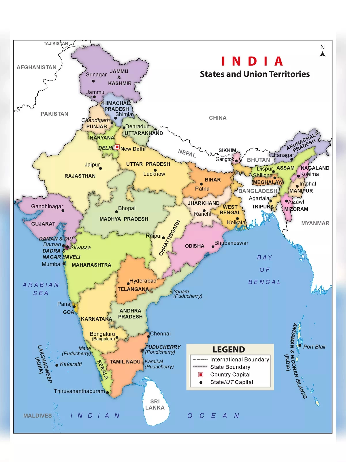
India Map with States & Capital 2026
India is located in southern Asia. It is bordered by the Arabian Sea, Laccadive Sea, and the Bay of Bengal to the south; Bhutan, Nepal, China, and Pakistan to the north; and Bangladesh and Myanmar (Burma) to the east. Understanding the India map with states and capital is crucial for students and anyone interested in learning more about this diverse country.
All States and Union Territories in India
The India political map showcases all the states and union territories along with their respective capital cities. India has a total of 28 states and 8 union territories, each with its unique culture and history. Let’s look at the details in the table below.
| States and Capitals of India 2026 (Updated) | |||
|---|---|---|---|
| S. No | States Name | Capital | Founded on |
| 1 | Andhra Pradesh | Hyderabad (Proposed Capital Amaravati) | 1 Nov. 1956 |
| 2 | Arunachal Pradesh | Itanagar | 20 Feb. 1987 |
| 3 | Assam | Dispur | 26 Jan. 1950 |
| 4 | Bihar | Patna | 26 Jan. 1950 |
| 5 | Chhattisgarh | Raipur | 1 Nov. 2000 |
| 6 | Goa | Panaji | 30 May. 1987 |
| 7 | Gujarat | Gandhinagar | 1 May. 1960 |
| 8 | Haryana | Chandigarh | 1 Nov. 1966 |
| 9 | Himachal Pradesh | Shimla | 25 Jan. 1971 |
| 10 | Jharkhand | Ranchi | 15 Nov. 2000 |
| 11 | Karnataka | Bengaluru (formerly Bangalore) | 1 Nov. 1956 |
| 12 | Kerala | Thiruvananthapuram | 1 Nov. 1956 |
| 13 | Madhya Pradesh | Bhopal | 1 Nov. 1956 |
| 14 | Maharashtra | Mumbai | 1 May. 1960 |
| 15 | Manipur | Imphal | 21 Jan. 1972 |
| 16 | Meghalaya | Shillong | 21 Jan. 1972 |
| 17 | Mizoram | Aizawl | 20 Feb. 1987 |
| 18 | Nagaland | Kohima | 1 Dec. 1963 |
| 19 | Odisha | Bhubaneswar | 26 Jan. 1950 |
| 20 | Punjab | Chandigarh | 1 Nov. 1956 |
| 21 | Rajasthan | Jaipur | 1 Nov. 1956 |
| 22 | Sikkim | Gangtok | 16 May. 1975 |
| 23 | Tamil Nadu | Chennai | 26 Jan. 1950 |
| 24 | Telangana | Hyderabad | 2 Jun. 2014 |
| 25 | Tripura | Agartala | 21 Jan. 1972 |
| 26 | Uttar Pradesh | Lucknow | 26 Jan. 1950 |
| 27 | Uttarakhand | Dehradun (Winter), Gairsain (Summer) | 9 Nov. 2000 |
| 28 | West Bengal | Kolkata | 1 Nov. 1956 |
| Union Territories and Capitals | |||
| Union Territories Names | Capital | Founded on | |
| 29 | Andaman and Nicobar Islands | Port Blair | 1 Nov. 1956 |
| 30 | Chandigarh | Chandigarh | 1 Nov. 1966 |
| 31 | Dadra & Nagar Haveli and Daman & Diu | Daman | 26 Jan. 2020 |
| 32 | Delhi | New Delhi | 9 May. 1905 |
| 33 | Jammu and Kashmir | Srinagar (Summer), Jammu (Winter) | 31-Oct-19 |
| 34 | Lakshadweep | Kavaratti | 1 Nov. 1956 |
| 35 | Puducherry | Pondicherry | 1 Nov. 1954 |
| 36 | Ladakh | Leh | 31-Oct-19 |
Download the India Map with States & Capital 2026 PDF using the link given below.