Delhi Mumbai Expressway Route Map
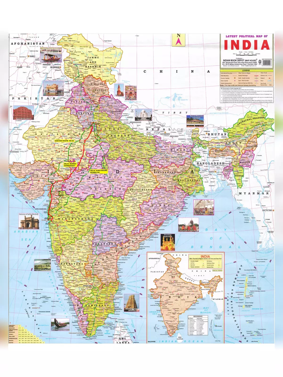
The Delhi – Mumbai Expressway (DME) project is an exciting under-construction 8-lane access-controlled road, spanning 1350 km. It connects the DND in Delhi directly to JNPT in Mumbai, aiming to transform travel. Designed for a speed limit of 120 km/hr, there’s room to expand it to 12 lanes in the future. This expressway shortens the distance between Delhi and Mumbai by about 150 km, bringing travel time down from 24 hours to just 13 hours. In addition, the expressway promises significant fuel savings, enhanced ride quality, and better safety compared to the older NH-48 (previously NH-8) highway. 🚗
Sections of the Expressway
The entire expressway is divided into four main sections comprising a total of 52 tenders/packages, each with a deadline of 24 months (2 years):
- DND – Faridabad – Sohna: 3 (60 km)
- Sohna – Vadodara: 31 (844 km)
- Vadodara – Virar: 13 (354 km)
- Virar – JNPT: 5 (92 km)
Delhi Mumbai Expressway Map
This expressway uses closed tolling and will connect five states: Haryana (80 km), Rajasthan (380 km), Madhya Pradesh (370 km), Gujarat (300 km), and Maharashtra (120 km). New industrial townships and Smart Cities are planned along its route, along with 92 rest areas on both sides spaced at approximately 50 km intervals.
This new greenfield expressway was approved for construction under the Bharatmala Pariyojana program in 2017. The foundation stone was laid by Prime Minister Narendra Modi on March 9, 2019.
- Total Estimated Cost: Rs. 1,00,000 crore (1 lakh crore)
- Project’s Total Length: 1350 km
- Lanes: 8 (expandable to 12)
- Speed Limit: 120 km/h
- Scheduled Opening / Deadline: January 26, 2023
- My Completion Estimate: 2024-end
- Owner: National Highway Authority of India (NHAI)
- Delhi – Vadodara Project Model: EPC (Engineering, Procurement & Construction)
- Vadodara – Mumbai Project Model: HAM (Hybrid Annuity Model)
- Status: Under Construction (687 km), Bidding & Land Acquisition
Delhi Mumbai Expressway Village List
| S.no | Village | Forest Land (ha) | Non-Forest Land (ha) |
|---|---|---|---|
| 1 | Alipur | 4.0348 | 23.0914 |
| 2 | Dhunela | 1.7087 | 3.9472 |
| 3 | Phulawas | 0 | 4.0302 |
| 4 | Berka | 0 | 0.0393 |
| 5 | Gadhi Bajidpur | 0 | 5.2337 |
| 6 | Abheypur | 0 | 21.0757 |
| 7 | Sirsaka | 0 | 1.0445 |
| 8 | Lothaki | 0.0963 | 3.0953 |
| 9 | Daula | 0.0804 | 22.1053 |
| 10 | Baluda | 0.0751 | 20.6045 |
| 11 | Sancholi | 1.2417 | 27.5135 |
| 12 | Bhirawati | 0 | 5.4745 |
| 13 | Hilalpur | 0.2423 | 30.1779 |
| 14 | Kaliyaka | 0.1106 | 10.7515 |
| 15 | Uleta | 0.2113 | 9.8314 |
| 16 | Hasanpur Sohna | 0.1961 | 27.8358 |
| 17 | Khalilpur | 0 | 40.5571 |
| 18 | Kurthala | 0.1849 | 19.167 |
| 19 | Golpuri | 0 | 14.3748 |
| 20 | Noshera | 0.27 | 18.5736 |
| 21 | Joisinghpur | 0.064 | 24.8177 |
| 22 | Sanghel | 1.9666 | 1.9761 |
| 23 | Partap Nagar | 1.1565 | 6.4608 |
| 24 | Bhajera | 0.2418 | 9.2457 |
| 25 | Devla Nangli | 0.6307 | 21.3564 |
| 26 | Rithath | 0.0928 | 15.6856 |
| 27 | Umri | 0.1391 | 11.2262 |
| 28 | Sukhpiri | 0.3039 | 3.96 |
| 29 | Ranyala Patakpur | 0.0912 | 19.9486 |
| 30 | Dandli Kalan | 0.0659 | 10.8012 |
| 31 | Dadola | 0 | 4.2209 |
| 32 | Khanpur Ghati | 0 | 6.8435 |
| 33 | Marora | 0.2007 | 22.9144 |
| 34 | Jhimrawat | 0.0781 | 30.5152 |
| 35 | Basai Khanzada | 0.0952 | 4.0726 |
| 36 | Khedli Kalan | 0.0719 | 13.347 |
| 37 | Gujjar Nangla | 0 | 3.4142 |
| 38 | Bai Khara | 0 | 10.2045 |
| 39 | Mahun | 0.0688 | 21.5617 |
| 40 | Chitora | 0 | 8.2445 |
| 41 | Naharika | 0 | 15.1639 |
| 42 | Rawa | 0 | 35.6495 |
| 43 | Baghola | 0.3137 | 12.7354 |
| 44 | Hirwadi Bamantheri | 0 | 20.6834 |
| 45 | Alipur Tigra | 0 | 8.5451 |
| 46 | Ghata Samsabad | 0.2828 | 12.6807 |
| 47 | Akhnaka | 0 | 12.3466 |
| 48 | Rigar | 0 | 30.5269 |
| 49 | Agon | 3.8735 | 19.9512 |
| 50 | Pathrali | 0 | 8.4342 |
| 51 | Shahpur | 0 | 6.1935 |
| 52 | Khedla Kalan | 0 | 6.2289 |
| 53 | Bhakroji | 0 | 15.9706 |
| 54 | Bariabas | 0 | 5.3008 |
| 55 | Ibrahambas | 0 | 3.7783 |
| 56 | Smirbas | 0.4117 | 17.0637 |
| 57 | Koligaon | 0 | 6.3781 |
| 58 | Mindkola | 0.7582 | 57.6784 |
| 59 | Ribbar | 0 | 3.7682 |
| 60 | Pondari | 0.8247 | 13.2391 |
| 61 | Akbarpur Natol | 0.0389 | 4.7586 |
| 62 | Bighwali | 0.2475 | 16.2694 |
| 63 | Chandaka | 0 | 0.7132 |
| 64 | Mirka | 0 | 3.6392 |
| 65 | Kalanjar | 0.2146 | 21.8253 |
| Total | 20.685 | 918.8632 | |
You can download the Delhi Mumbai Expressway Route Map in PDF format using the link given below or find an alternative link for more details.