Delhi Metro Route Map
The Delhi Metro is a rapid transit system serving the National Capital Region (NCR) of India. Metro Rail network consists of 10 color-coded lines serving 255 stations with a total length of 390.14 kilometers (242 mi), and 286 stations, including the Gurugram Metro and Noida Metro.
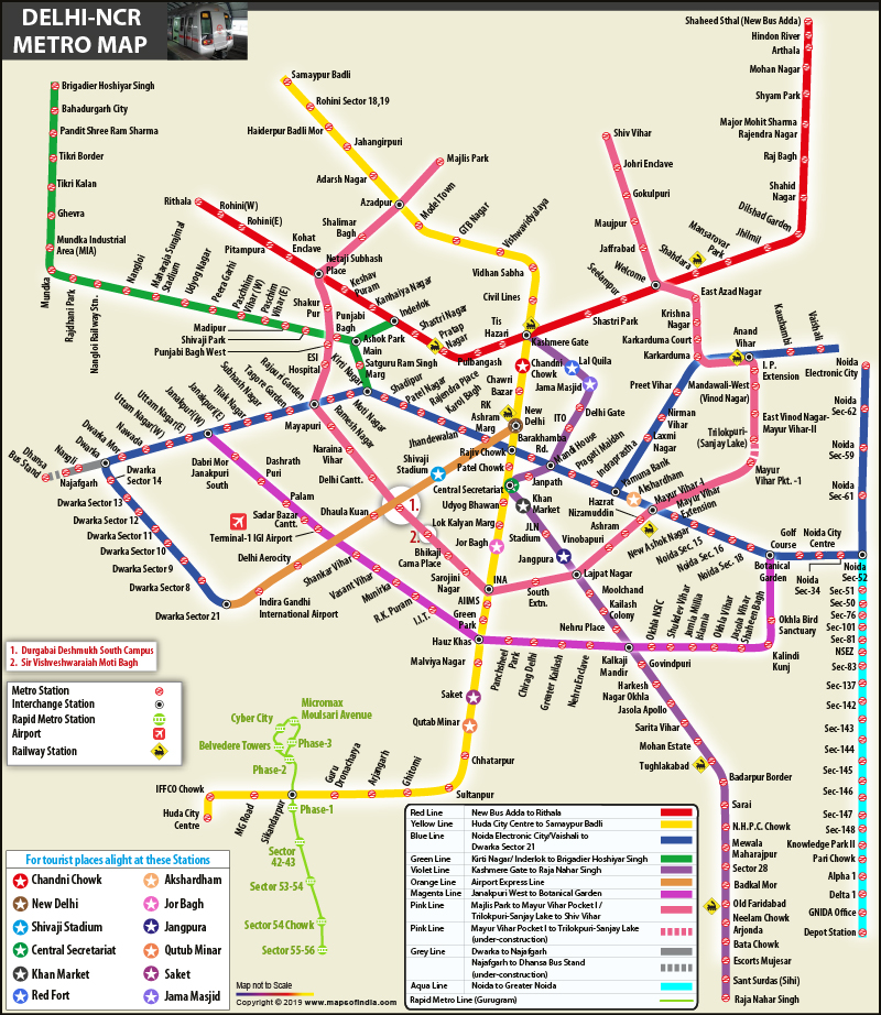
Delhi Metro Line Map
- Red Line (Line 1): Rithala to Shaheed Sthal (New Bus Adda)
- Yellow Line (Line 2): Samaypur Badli to HUDA City Centre
- Blue Line (Line 3/4): Dwarka Sector 21 to Noida Electronic City / Vaishali
- Green Line (Line 5): Inderlok/Kirti Nagar to Brigadier Hoshiar Singh
- Violet Line (Line 6): Kashmere Gate to Raja Nahar Singh (Ballabhgarh)
- Orange Line (Airport Express Line): New Delhi to Dwarka Sector 21
- Pink Line (Line 7): Majlis Park to Shiv Vihar
- Magenta Line (Line 8): Janakpuri West to Botanical Garden
- Grey Line (Line 9): Dwarka to Dhansa Bus Stand
- Aqua Line: Noida Sector 51 to Greater Noida Depot (operated by Noida Metro)
Delhi Metro Station Route List
- Noida Electronic City
- Noida Sector 62
- Noida Sector 59
- Noida Sector 61
- Noida Sector 52
- Noida Sector 34
- Noida City Centre
- Noida Golf Course
- Botanical Garden
- Noida Sector 18
- Noida Sector 16
- Noida Sector 15
- New Ashok Nagar
- Mayur Vihar Extension
- Mayur Vihar-I
- Akshardham
- Yamuna Bank
- Indraprastha
- Pragati Maidan
- Mandi House
- Barakhamba Road
- Rajiv Chowk
- R K Ashram Marg
- Jhandewalan
- Karol Bagh
- Rajendra Place
- Patel Nagar
- Shadipur
- Kirti Nagar
- Moti Nagar
- Ramesh Nagar
- Rajouri Garden
- Tagore Garden
- Subhash Nagar
- Janakpuri East
- Janakpuri West
- Uttam Nagar East
- Uttam Nagar West
- Nawada
- Dwarka Mor
- Dwarka
- Dwarka Sector 14
- Dwarka Sector 13
- Dwarka Sector 12
- Dwarka Sector 11
- Dwarka Sector 10
- Dwarka Sector 9
- Dwarka Sector 8
- Dwarka Sector 21
Delhi-NCR Metro Route Map
