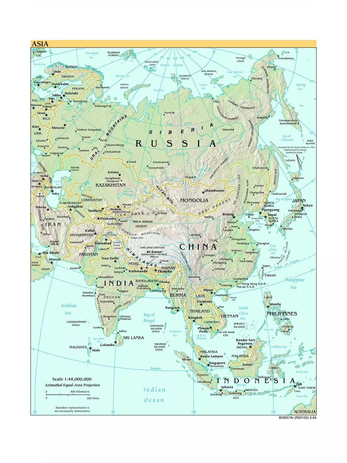
Asia Political Map
Asia is the largest continent in the world, covering nearly one-third of Earth’s total landmass. It lies mostly north of the equator, with some exceptions found in Southeast Asian islands.
Understanding the Asia Political Map
The continent of Asia occupies a significant part of Eurasia, which is the largest single landmass on Earth. The Malay Archipelago is also included as a part of Asia due to its geographical location. To the west, Asia borders Europe, sharing the Ural Mountains and the Caspian Sea.
On the eastern side, Asia is bordered by the Pacific Ocean, while the Indian Ocean lies to the south, and the Arctic Ocean is found to the north. The boundary between Asia and Europe is more a matter of history and culture than a strict physical division, as there is no clear geographical separation. This boundary has shifted over time since its early identification in classical antiquity.
Asia Political Map – High Quality / Printable Political Map of Asia
The total area of Asia is approximately 49,700,000 km² (19,189,277 sq mi), accounting for about 30 percent of the Earth’s land area. The population of Asia exceeds 4.6 billion people (as of 2020), making up around 60 percent of the world’s total population.
The highest point in Asia is Sagarmatha (commonly known as Mount Everest), standing at 8,848 meters (29,028 feet) along the China–Nepal border.
The largest lakes in Asia include the Caspian Sea, which is a saltwater lake covering 371,000 km² (143,250 sq mi), and Lake Baikal (Ozero Baykal) in Siberia, recognized as the world’s largest freshwater lake by volume with an area of 31,500 km².
Asian Sub-regions Depicted on the Map
- North Asia: This region, also known as Northern Asia, is part of the Russian Federation located east of the Ural Mountains. It includes the Ural region, Siberia, and the Russian Far East, covering an area of 13.1 million km², which accounts for about 77% of Russia’s territory.
- Central Asia: This region is home to the ‘stan-countries,’ which were former Soviet republics. These include Kazakhstan, Kyrgyzstan, Tajikistan, Turkmenistan, and Uzbekistan. Some definitions may also include Afghanistan.
- South Asia: The South Asia region includes countries such as Afghanistan, Bangladesh, Bhutan, India, Maldives, Nepal, Pakistan, and Sri Lanka.
- East Asia: East Asia comprises nations like China (including special administrative regions such as Hong Kong, Macau, and Tibet), Japan, Mongolia, North Korea (Democratic People’s Republic of Korea), South Korea (Republic of Korea), and Taiwan (Republic of China).
You can download the high-resolution Asia Political Map PDF using the link given below, perfect for educational and reference purposes!