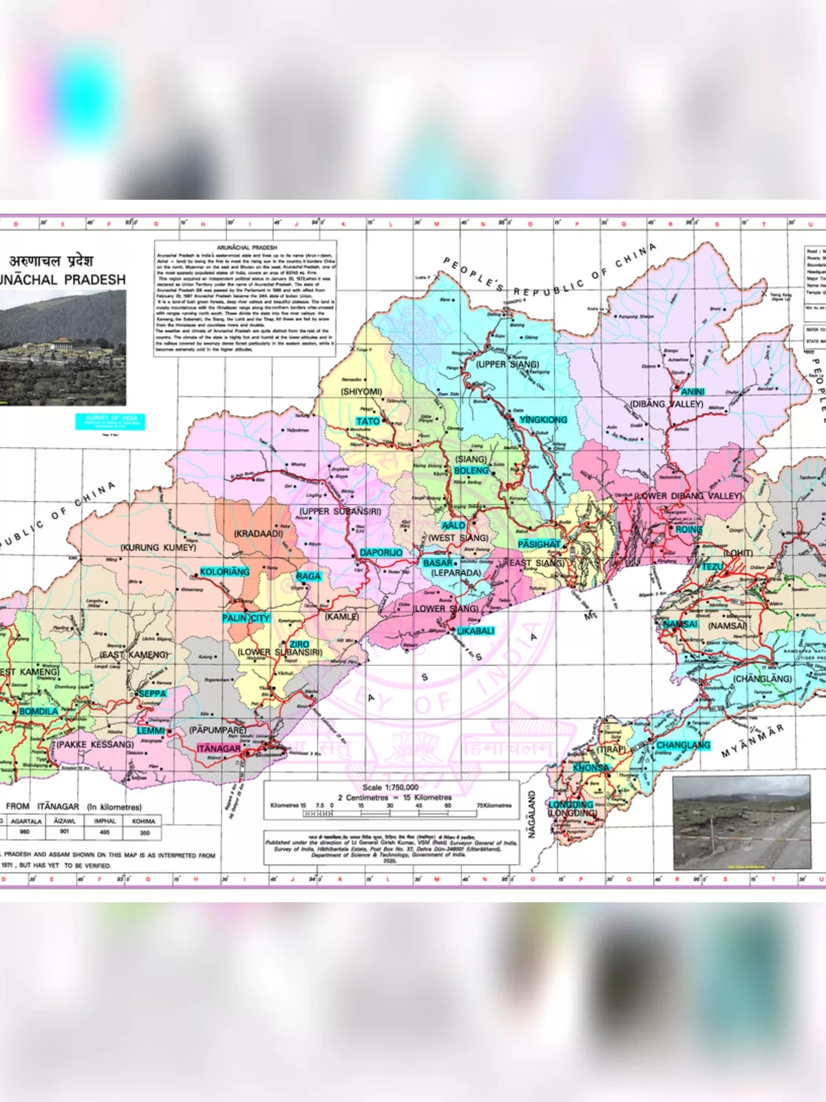
Arunachal Pradesh Map with New Districts
Discover the Arunachal Pradesh map with new districts, showcasing this beautiful northeastern state of India. Covering nearly 84,000 sq km, Arunachal Pradesh shares lengthy international borders with Bhutan to the west (160km), China to the north and northeast (1,080 km), and Myanmar to the east (440km). From the snow-capped mountains in the north to the serene plains of the Brahmaputra valley in the south, it is the largest state by area in the northeastern region—larger than Assam, which has a greater population.
About Arunachal Pradesh
Nestled at the tip of northeastern India, Arunachal Pradesh shares immense borders with Assam and Nagaland in the south. In addition to its connections with these states, it has international borders with Bhutan to the west, Myanmar to the east, and a disputed boundary with China in the north known as the McMahon Line. Arunachal Pradesh is notable for being the largest state area-wise in the northeast region.
Arunachal Pradesh Map
The state of Arunachal Pradesh spans an area of 83,743 km² (32,333 sq mi), ranking 14th in total area across India. The geography transitions from the snow-covered Himalayas to the fertile plains of the Brahmaputra. Geographically, it lies between latitudes 26° 30′ and 29° 30′ North, and longitudes 91° 30′ and 97° 30′ East.
Primarily an agricultural state, Arunachal Pradesh grows various main crops including rice, pulses, sugarcane, wheat, millets, and oilseeds. The state’s major rivers, such as the Brahmaputra, Subansiri, Lohit, Kameng, and Tirap, originate from the Himalayas and flow through five key river valleys: the Kameng, Subansiri, Siang, Lohit, and Tirap.
Arunachal Pradesh Map – Overview
| Capital | Itanagar |
| Governor | Brigadier BD Mishra (Retd) |
| Chief Minister | Pema Khandu |
| Tourist attractions | Tawang Monastery, Dirang, Bomdila |
| Festivals | Losar, Si-Donyi, Reh, Mopin, and Solung |
| Major dance and music forms | Lion and Peacock dance, Ponung, Roppi, Wancho dance |
| Arts and crafts | The Monpas excel in wood carving, while women in AP are skilled weavers. |
| Languages | Monpa, Mild, Aka, Sherdukpen, Apatani, Adi, Hill Miri |
| Size | 83,743 sq. km |
| Population (Census 2011) | 1,382,611 |
| Rivers | Siang, Lohit, Kameng, Dikrong, Tirap, Dibang, Subansiri, Noa-Dihing, Kamlang |
| Forests and wildlife sanctuaries | Namdapha NP, Monling NP |
| State animal | Mithun |
| State bird | Great Indian hornbill |
| State flower | Rhynchostylis retusa |
| State tree | Dipterocarpus retusus |
| Major crops | Jhum |
| Factoids | The mithun is seen as a symbol of wealth and is kept free until sacrificed to celebrate special occasions. |
| Monpas, who practice Buddhism, inhabit the mountainous regions of western Arunachal Pradesh. | |
| No. of Districts | 25 |
You can download the Arunachal Pradesh Map PDF using the link provided below.